
NonLinLoc
NonLinLoc locator wrapper plugin for SeisComP. NonLinLoc was written by Anthony Lomax (http://alomax.free.fr/nlloc).
Description
Funded by SED/ETH Zurich, developed by [32]. This plugin is available from SeisComP version Release Potsdam 2010 and later.
The NonLinLoc (NLL) locator algorithm has been implemented into SeisComP through the plugin mechanism. A new plugin locnll contains the LocatorInterface implementation for NonLinLoc.
The implementation bundles the NonLinLoc source files required to use the library function calls. The following source files are included:
GridLib.c
GridLib.h
GridMemLib.c
GridMemLib.h
NLLocLib.h
NLLoc1.c
NLLocLib.c
calc_crust_corr.c
calc_crust_corr.h
crust_corr_model.h
crust_type_key.h
crust_type.h
loclist.c
octtree.h
octtree.c
phaseloclist.h
phaselist.c
geo.c
geo.h
geometry.h
map_project.c
map_project.h
otime_limit.c
otime_limit.h
ran1.c
ran1.h
velmod.c
velmod.h
util.h
util.c
alomax_matrix/alomax_matrix.c
alomax_matrix/alomax_matrix.h
alomax_matrix/alomax_matrix_svd.c
alomax_matrix/alomax_matrix_svd.h
Error measures
After running NonLinLoc the output is converted into a SeisComP (QuakeML) origin object including all available error measures. The following table shows how the NLL error measures are mapped to the SeisComP data model:
SeisComP |
NLL |
|---|---|
Origin.latitude.uncertainty |
sqrt(phypo->cov.yy) |
Origin.longitude.uncertainty |
sqrt(phypo->cov.xx) |
Origin.depth.uncertainty |
sqrt(phypo->cov.zz) |
Origin.originQuality.standardError |
phypo->rms |
Origin.originQuality.secondaryAzimuthalGap |
phypo->gap_secondary |
Origin.originQuality.usedStationCount |
phypo->usedStationCount |
Origin.originQuality.associatedStationCount |
phypo->associatedStationCount |
Origin.originQuality.associatedPhaseCount |
phypo->associatedPhaseCount |
Origin.originQuality.usedPhaseCount |
phypo->nreadings |
Origin.originQuality.depthPhaseCount |
phypo->depthPhaseCount |
Origin.originQuality.minimumDistance |
km2deg(phypo->minimumDistance) |
Origin.originQuality.maximumDistance |
km2deg(phypo->maximumDistance) |
Origin.originQuality.medianDistance |
km2deg(phypo->medianDistance) |
Origin.originQuality.groundTruthLevel |
phypo->groundTruthLevel |
Origin.originUncertainty.horizontalUncertainty |
phypo->ellipse.len2 |
Origin.originUncertainty.minHorizontalUncertainty |
phypo->ellipse.len1 |
Origin.originUncertainty.maxHorizontalUncertainty |
phypo->ellipse.len2 |
Origin.originUncertainty.azimuthMaxHorizontalUncertainty |
phypo->ellipse.az1 + 90 |
ConfidenceEllipsoid.semiMajorAxisLength |
phypo->ellipsoid.len3 |
ConfidenceEllipsoid.semiMinorAxisLength |
phypo->ellipsoid.len1 |
ConfidenceEllipsoid.semiIntermediateAxisLength |
phypo->ellipsoid.len2 |
ConfidenceEllipsoid.majorAxisPlunge |
(phypo->ellipsoid.axis1 x phypo->ellipsoid.axis2).dip |
ConfidenceEllipsoid.majorAxisAzimuth |
(phypo->ellipsoid.axis1 x phypo->ellipsoid.axis2).az |
ConfidenceEllipsoid.majorAxisRotation |
T.B.D. |
Plugin
The NonLinLoc plugin is installed under share/plugins/locnll.so.
It provides a new implementation of the LocatorInterface with the name NonLinLoc.
To add the plugin to a module add it to the modules configuration, either
modulename.cfg or global.cfg:
plugins = ${plugins}, locnll
Output
All output is stored in the configured NonLinLoc.outputPath.
The file prefix for a location is the originID (NonLinLoc.publicID).
The following file are stored:
Input observations (.obs)
Input configuration (.conf)
NLL location (.loc.hyp)
NLL 3D grid header (.loc.hdr)
NLL octree (.loc.octree)
NLL scatter file (.loc.scat)
In addition to the native NLL output a SeisComP origin object is created and returned to the calling instance. Usually this object is then sent via messaging.
Setup
Profiles
The plugin allows to specify multiple configuration profiles (NonLinLoc.profiles).
The profile to use can selected both in scolv and screloc, however a
virtual profile automatic is also provided, which selects the best matching
configured profile based on the initial location. For this reason each profile
contains some configuration parameters that defines where the profile is valid
(transform, region, origin, rotation). The transform profile
configuration parameter supports only GLOBAL or SIMPLE at the moment: only the
profile has this limitation, not the NonLinLoc control file, which supports
all transformations available in NonLinLoc.
Note
If a profile transform is set as GLOBAL and the region parameter is left empty, then the plugin adds the line TRANS GLOBAL to the control file, forcing a global transformation.
Configuration example
To add the plugin to an application such as scolv or screloc, add the plugin
name to the list of plugins that are loaded (e.g. scolv.cfg):
plugins = ${plugins}, locnll
Futhermore add the plugin configuration (e.g. scolv.cfg):
########################################################
################ NonLinLoc configuration################
########################################################
NLLROOT = ${HOME}/nll/data
NonLinLoc.outputPath = ${NLLROOT}/output/
# Define the default control file if no profile specific
# control file is defined.
NonLinLoc.controlFile = ${NLLROOT}/NLL.default.conf
# Set the default pick error in seconds passed to NonLinLoc
# if no SeisComP pick uncertainty is available.
NonLinLoc.defaultPickError = 0.1
# Define the available NonLinLoc location profiles. The order
# implicitly defines the priority for overlapping regions
#NonLinLoc.profiles = swiss_3d, swiss_1d, global
NonLinLoc.profiles = swiss_3d, global
# The earthModelID is copied to earthModelID attribute of the
# resulting origin
NonLinLoc.profile.swiss_1d.earthModelID = "swiss regional 1D"
# Specify the velocity model table path as used by NonLinLoc
NonLinLoc.profile.swiss_1d.tablePath = ${NLLROOT}/time_1d_regio/regio
# Specify the region valid for this profile
# Without this parameter the plugin will add an additional
# TRANS GLOBAL statement in the NLL control file
NonLinLoc.profile.swiss_1d.region = 41.2, 3.8, 50.1, 16.8
# The NonLinLoc control file to use for this profile
NonLinLoc.profile.swiss_1d.controlFile = ${NLLROOT}/NLL.swiss_1d.conf
# Configure the swiss_3d profile
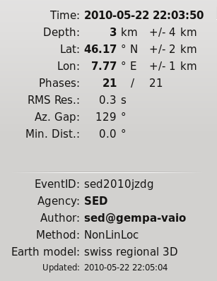
NonLinLoc.profile.swiss_3d.earthModelID = "swiss regional 3D"
NonLinLoc.profile.swiss_3d.tablePath = ${NLLROOT}/time_3d/ch
NonLinLoc.profile.swiss_3d.region = 45.15, 5.7, 48.3, 11.0
NonLinLoc.profile.swiss_3d.controlFile = ${NLLROOT}/NLL.swiss_3d.conf
# And the global profile
NonLinLoc.profile.global.earthModelID = iaspei91
NonLinLoc.profile.global.tablePath = ${NLLROOT}/iasp91/iasp91
NonLinLoc.profile.global.controlFile = ${NLLROOT}/NLL.global.conf
An example of a NonLinLoc control file configuration that contains all the required statements, but it must be adapted to the specific use case. The missing statements are generated by the plugin (LOCFILES, LOCHYPOUT, LOCSRCE):
# -1 = no logs, useful for playback with screloc --ep option
CONTROL -1 123456
# This must be the same TRANS used for generating the grid files
TRANS SDC 46.51036987 8.47575546 0.0
LOCSIG Swiss Seismological Service, ETHZ
LOCCOM location using my local velocity model
LOCSEARCH OCT 20 20 20 0.001 10000 1000
# This grid origin is relative to the TRANS statement. The grid
# must be wholly contained in the grid files
LOCGRID 101 101 101 -0.5 -0.5 -1.8  0.01 0.01 0.01 PROB_DENSITY SAVE
LOCMETH EDT_OT_WT 9999.0 4 -1 -1 -1 0 -1 1
LOCGAU 0.001 0.0
LOCPHASEID  P   P p G Pn Pg P1
LOCPHASEID  S   S s G Sn Sg S1
LOCQUAL2ERR 0.025 0.050 0.100 0.200 0.400 99999.9
LOCANGLES ANGLES_YES 5
Note
The LOCHYPOUT parameter statement is always generated by the plugin. By default it outputs LOCHYPOUT NONE. If enableSEDParameters is enabled or if the original control file contains CALC_SED_ORIGIN, it will append CALC_SED_ORIGIN. If the original control file contains SAVE_NLLOC_EXPECTATION, that flag will also be preserved. Currently, only CALC_SED_ORIGIN and SAVE_NLLOC_EXPECTATION are supported by the plugin. Any other options are omitted and will not be forwarded to NonLinLoc.
Testing
After setting the SeisComP module configuration parameters for NonLinLoc you may test your settings by selecting NonLinLoc in scolv. The configuration along with errors and missing files will be reported in the log output. In case of issues adjust your configuration or the file/directory structure accordingly. Example:
scolv --debug --olv.locator=NonLinLoc

...
15:48:05 [debug] NonLinLoc profile configurations
15:48:05 [debug] ================================
15:48:05 [debug] Parameters for profile 'global'
15:48:05 [debug]   + Earth model                              : iasp91
15:48:05 [debug]   + method                                   : NonLinLoc
15:48:05 [debug]   + table path                               : /home/sysop/seiscomp/share/nonlinloc/iasp91/iasp91_1
15:48:05 [debug]   + testing existence of files in directory  : /home/sysop/seiscomp/share/nonlinloc/iasp91
15:48:05 [error]     + found no files starting with           : /home/sysop/seiscomp/share/nonlinloc/iasp91/iasp91_1
15:48:05 [warning] + ignoring NonLinLoc profile 'global'
15:48:05 [debug] Parameters for profile 'm1'
15:48:05 [debug]   + Earth model                              : led1
15:48:05 [debug]   + method                                   : NonLinLoc
15:48:05 [debug]   + table path                               : /home/sysop/seiscomp/share/nonlinloc/m1/layer
15:48:05 [error]   + path to travel-time tables does not exist: /home/sysop/seiscomp/share/nonlinloc/m1
15:48:05 [warning] + ignoring NonLinLoc profile 'm1'
15:48:05 [debug] Parameters for profile 'm2'
15:48:05 [debug]   + Earth model                              : led2
15:48:05 [debug]   + method                                   : NonLinLoc
15:48:05 [debug]   + table path                               : /home/sysop/seiscomp/share/nonlinloc/m2/layer
15:48:05 [debug]   + testing existence of files in directory  : /home/sysop/seiscomp/share/nonlinloc/m2
15:48:05 [debug]     + found     8 files starting with        : /home/sysop/seiscomp/share/nonlinloc/m2/layer
15:48:05 [error]   + missing NonLinLoc.profile.m2.controlFile : /home/dirk/PROJEKTE/HLNUG/support/6803/NLL.LED2.conf2
15:48:05 [warning] + ignoring NonLinLoc profile 'm2'
15:48:05 [warning] NonLinLoc: Found no profiles
...
Stations names
When generating the grid files the station names used in the GTSRCE statement must match the rule set in the plugin configuration. E.g.
# Format of the station name used to select the right travel time table (grid)
# file for a station. By default only the station code is used (e.g.
# tablePath.P.@STA@.time.*), but that doesn't allow to distinguish between
# multiple network codes or location codes that use the same station code. To
# overcome this limitation this parameter could be set in a more general way,
# for example @NET@_@STA@_@LOC@. In this way NonLinLoc will look for travel
# time table (grid) files of the form: tablePath.P.@NET@_@STA@_@LOC@.time.*
# Where @NET@ @STA@ @LOC@ are just placeholder for the actual codes
NonLinLoc.profile.MYPROFILE.stationNameFormat = @NET@_@STA@_@LOC@
Given the above plugin configuration, the GTSRCE statement should be something like this:
GTSRCE CH_STA01_   LATLON  46.519  8.474  0.0  1.295
GTSRCE CH_STA02_01 LATLON  46.456  8.474  0.0  1.323
GTSRCE CH_STA03_AA LATLON  46.784  8.474  0.0  1.292
Alternatively the names could just contain the station code:
NonLinLoc.profile.MYPROFILE.stationNameFormat = @STA@
GTSRCE STA01 LATLON  46.519  8.474  0.0  1.295
GTSRCE STA02 LATLON  46.456  8.474  0.0  1.323
GTSRCE STA03 LATLON  46.784  8.474  0.0  1.292
Usage
Locator
The usage of the new NLL plugin is straight forward. Once loaded successfully the new locator shows up in the lower left corners combo box.
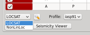
Select the new NonLinLoc locator and the configured profiles will be loaded into the combo box right of it.
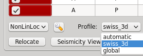
The NonLinLoc implementation provides a virtual profile automatic. This emulates the complete automatic case and selects the best matching configured profiles based on the initial location.
If an origin has been relocated the method should be set to “NonLinLoc” and the earth model contains the string NonLinLoc.profile.[name].earthModelID configured for the selected profile.
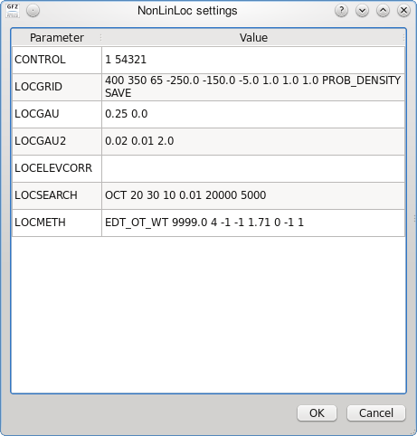
Settings
The NLL locator implementation supports to override configured settings or control parameters for a session. Those changes are not persistent and lost if the locator is changed to another one or the profile has been changed. However this feature is particularly useful when trying differnt settings on a particular origin or for enabling the NonLinLoc logs (CONTROL statement) that becomes visible on the console.
To open the settings dialog press the button right to the locator selection combo box.
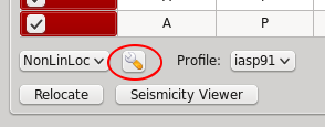
Then the NLL specific parameters show up.
Seismicity Viewer
scolv provides two additional configurable buttons. To bind Seismicity Viewer to the first one the following configuration can be used:
button0 = "Seismicity Viewer"
scripts.script0 = @CONFIGDIR@/scripts/sv
A small wrapper script sv has been created that calls Seismicity Viewer based on the origin ID passed to the script.
#!/bin/sh
FILE=$HOME/nll/data/output/$1.loc.hyp
java -classpath $HOME/nll/bin/SeismicityViewer50.jar \
     net.alomax.seismicity.Seismicity $FILE
This examples assumes that Seismicity Viewer has been installed in $HOME/nll/bin.
Module Configuration
- NonLinLoc.publicID
Default:
NLL.@time/%Y%m%d%H%M%S.%f@.@id@Type: string
PublicID creation pattern for an origin created by NonLinLoc.
- NonLinLoc.outputPath
Default:
/tmp/sc3.nllType: directory
Defines the output directory for all native NonLinLoc input and output files.
- NonLinLoc.saveInput
Default:
trueType: boolean
Save input files *.obs in outputPath for later processing. Setting to false reduces file i/o and saves disk space.
- NonLinLoc.saveIntermediateOutput
Default:
trueType: boolean
Save output files in outputPath for later processing or for viewing by the Seismicity Viewer. Setting to false reduces file i/o and saves disk space.
- NonLinLoc.controlFile
Type: file
The default NonLinLoc control file to use. Parameters therein are overridden per profile.
- NonLinLoc.defaultPickError
Default:
0.5Type: double
Unit: s
The default pick error in seconds passed to NonLinLoc if a SeisComP pick object does not provide pick time uncertainties.
- NonLinLoc.fixedDepthGridSpacing
Default:
0.1Type: double
Unit: km
Since NLL does not support fixing the depth natively so this feature is emulated by settings the Z grid very tight around the depth to be fixed. This value sets the Z grid spacing.
- NonLinLoc.allowMissingStations
Default:
trueType: boolean
Picks from stations with missing configuration will be ignored. The origin will be relocated without that pick if possible.
If set to false, the plug-in throws an excepection without locating.
- NonLinLoc.profiles
Type: list:string
Defines a list of active profiles to be used by the plugin.
Note
NonLinLoc.profile.$name.*
Defines a regional profile that is used if a prelocation falls
inside the configured region.
$name is a placeholder for the name to be used and needs to be added to NonLinLoc.profiles to become active.
NonLinLoc.profiles = a,b
NonLinLoc.profile.a.value1 = ...
NonLinLoc.profile.b.value1 = ...
# c is not active because it has not been added
# to the list of NonLinLoc.profiles
NonLinLoc.profile.c.value1 = ...
- NonLinLoc.profile.$name.earthModelID
Type: string
Earth model ID stored in the created origin.
- NonLinLoc.profile.$name.methodID
Default:
NonLinLocType: string
Method ID stored in the created origin.
- NonLinLoc.profile.$name.tablePath
Type: path
Path to travel time tables (grids) including the full path and the names of the table files before the phase name.
Example:
@DATADIR@/nonlinloc/iasp91/iasp91 for P and S tables files seiscomp/share/nonlinloc/iasp91/iasp91.[PS].*
- NonLinLoc.profile.$name.stationNameFormat
Default:
@STA@Type: string
Format of the station name used to select the right travel time table (grid) file for a station. By default only the station code is used (e.g. tablePath.P.@STA@.time.*), but that doesn’t allow to distinguish between multiple network codes or location codes that use the same station code. To overcome this limitation this parameter could be set in a more general way, for example @NET@_@STA@_@LOC@. In this way NonLinLoc will look for travel time table (grid) files of the form: tablePath.P.@NET@_@STA@_@LOC@.time.* Where @NET@ @STA@ @LOC@ are just placeholder for the actual codes.
- NonLinLoc.profile.$name.controlFile
Type: file
Control file of the current profile overriding parameters of the default control file.
- NonLinLoc.profile.$name.transform
Default:
GLOBALType: string
Transformation type of the configured region. Supported are SIMPLE and GLOBAL.
- NonLinLoc.profile.$name.region
Type: list:double
Defines the 4 corner values of the epicentral region for selecting the profile. The original epicentre must be within the region.
If transform is GLOBAL: min_lat, min_lon, max_lat, max_lon. The values define the geographic corner coordinates. Unit: degree.
If transform is SIMPLE: min_x, min_y, max_x, max_y. The values define the region relative to the origin configured with "origin". Unit: km.
When this parameter is empty, the generated NonLinLoc configuration is automatically overwritten with TRANS GLOBAL. Otherwise TRANS from "controlFile" applies.
- NonLinLoc.profile.$name.origin
Type: list:double
Unit: deg
Only used for transformation SIMPLE. Expects 2 values: latitude, longitude. The value define the geographic origin of the area spanned by region.
- NonLinLoc.profile.$name.rotation
Type: double
Unit: deg
Only used for transformation SIMPLE. Defines the rotation around the origin of the defined region.

