
GUI
The GUI configuration plugin extends the configuration of graphical user interfaces to various options to adjust the look and feel.
Description
All SeisComP graphical user interfaces are based on a common libraries. This chapter describes what configuration and styling options are available for all GUI applications. The GUI specific configuration options are additional to the standard application options. Setup the e.g., messaging connection and database is equal to the CLI (command line interface) applications.
Styling
To adjust the look-and-feel to the host desktop system and the personal taste several styling options are available. Since all GUI applications are using the Qt library, the tool “qtconfig” can used to adjust the widget theme and the colors. If KDE is used as desktop system, the same style is used since KDE bases on Qt as well.
The style options supported by SeisComP (and not covered by the general Qt setup) have to be given in the applications (or global) configuration file. The parameters are configured with the scheme. parameters.
In case of map layers defined by geo feature files the
parameters may also be defined by map.cfg in the directory of the geo
feature file.
Configuration syntax
Beside the usual integer, float, boolean and string parameters GUI applications support also color, color gradient, pen, brush, font and symbol parameters. The syntax is explained below:
Colors
color = red | RRGGBB | RRGGBBAA | "rgb(red,green,blue)" | "rgba(red,green,blue,alpha)"
Colors are specified either by color keyword names, in a hexadecimal notation or in a rgb(a) notation. When using the rgb(a) notation it should be quoted. Otherwise the configuration parser would tokenize the value into 3 or 4 strings due to the comma.
Color gradients
gradient = 1:FF0000, 2:00FF00, 3:0000FF
This defines a gradient from red through green to blue for the nodes 1, 2 and 3. Values out of range are clipped to the lower or upper bound.
Fonts
# The font family
font.family = "Arial"

# Point size
font.size = 12

# Bold?
# Default: false
font.bold = false

# Italic?
# Default: false
font.italic = false

# Underline?
# Default: false
font.underline = false

# Overline?
# Default: false
font.overline = false
An example to configure the SC3 base font:
scheme.fonts.base.family = "Arial"
scheme.fonts.base.size = 10
Pens
Pens are used in the vector layer configuration. Pens have three attributes: color, style and width. Color follows the described color definition, width is a double and the styles are:
|

|
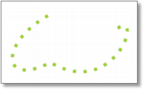
|
nopen |
solidline |
dotline |
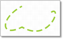
|
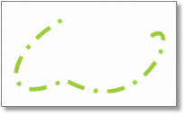
|
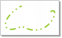
|
dashline |
dashdotline |
dashdotdotline |
Images from Qt 4.1 documentation: http://doc.qt.digia.com/4.1/qt.html#PenStyle-enum |
||
Example:
# Blue dotted pen
pen.color = 0000ff
pen.style = dotline
Brushes
Brushes are also used in the vector layer configuration. Brushes are used to fill a polygon. They have two attributes: color and style. Color follows the described color definition and styles are:
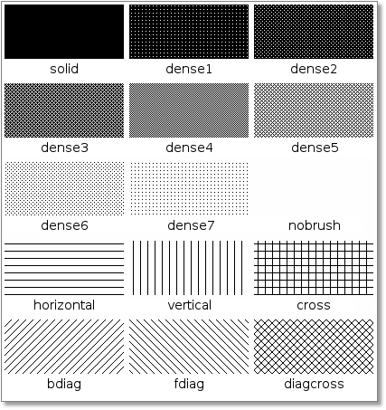
Example:
# Red solid brush
brush.color = ff0000
brush.style = solid
Symbols
Symbols configured by the symbol.* parameters can be plotted on coordinate
points defined by geo feature files or by symbol.icon.hotspot.x
and symbol.icon.hotspot.y. The symbols can be shapes (symbol.shape)
or icons from a file (symbol.icon).
Legends
Legends are plotted on maps describing map vector layers. Styles are:
Name |
Description |
Example |
|---|---|---|
Title |
title = Faults |
|
Orientation: vertical, horizontal |
orientation = vertical |
|
Position: topleft, topright, bottomleft, bottomright |
legendArea = topleft |
Map Layers
Additional features may be added to maps using configurable layers:
Vector layers, e.g., points, polylines, polygons from FEP, BNA or GeoJSON files. Files in BNA and GeoJSON format can be generated from other formats by many GIS programs or web sites. BNA and GeoJSON are described below.
Other layers, e.g., cities, grids, events, custom layers.
Vector layers are loaded and may be visualized together with
other layers. The order of the drawing is defined
by map.layers.
The map layers can be explained on the maps by configurable legends and selected interactively by their configurable category.
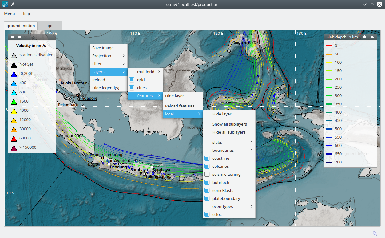
Map with layers defined by polygons, cities and legends.
Vector layers
Deprecation warning
The old directories @DATADIR@/bna or @CONFIGDIR@/bna
are still supported but superseded by @DATADIR@/spatial/vector or
@CONFIGDIR@/spatial/vector. The latter directories have higher priority.
If one of the old directories has been found, a warning will be logged.
SeisComP supports arbitrary polygons, polylines or points for drawing as layers on maps or for using by other modules and plugins. The polygons, polylines and points can be customized by the available attributes. Currently supported data formats are:
Note
Please note that segment lengths below 180 degrees must be used in order to render polygons or polylines correctly and to avoid representation ambiguities.
Data formats
Flinn-Engdahl polygons (FEP)
Used for visualization of event regions and for setting the region name of the event by scevent.
Stored in directories:
@DATADIR@/fepor@CONFIGDIR@/fepFile name extension: .fep
File format example with one polygon:
longitude1 latitude1
longitude2 latitude2
longitude3 latitude3
...
99.0 99.0 length
L name
where the coordinates, length and name are to be replaced by actual values,
Visibility and style can be controlled by configuration and
map.layers.fep.visible.
Boundary file format (BNA)
Used for visualization, e.g., points, polylines, polygons for faults or districts, respectively, and even symbols or images on maps. Some objects, like closed lines, can be evaluated by other modules and plugins, e.g,. the region check plugin for scevent.
Stored in directories or sub-directories of:
$SEISCOMP_ROOT/share/spatial/vectoror~/.seiscomp/spatial/vectorFile name extension: .bna
Properties are controlled as described in the section Layer configuration
For closed polygons the list of coordinates does not need to end on start coordinates.
File format example for one polygon/polyline:
"name 1","rank 1",type/length
longitude1,latitude1
longitude2,latitude2
longitude3,latitude3
...
where the coordinates, name and type/length are to be replaced by actual values. For polylines (open polygons) set type/length to the negative number of points defining the line, e.g., -10. Positive numbers, e.g., 10, define closed polygons. Such polygons are automatically closed between their end points. Thus, the end points do not need to be identical.
The BNA file format also supports multiple vertices per line and the definition of islands. Please refer to https://www.softwright.com/faq/support/boundary_file_bna_format.html for more format specifications.
Note
All SeisComP map applications support the drawing of polygons and a subsequent export to the BNA format.
An extension of the header entries is possible. The extra entries can be used by other modules or plugins, e.g., the region check plugin. Example
"coal","rank 1","eventType: mining explosion, minDepth: -5, maxDepth: 10",6
The name is extracted from the first part of the header.
The rank is extracted from the second part of the header if it has the form “rank VALUE”, e.g., rank 12.
Visibility and style can be controlled by configuration in map.cfg.
GeoJSON
Used for visualization, e.g., points, polylines, polygons for faults or districts, respectively, and even symbols or images on maps.
Stored in directories or sub-directories of:
$SEISCOMP_ROOT/share/spatial/vectoror~/.seiscomp/spatial/vectorFile name extension: .geojson
File format: https://geojson.org/
Note
All coordinates must be given in the WGS-84 coordinate reference frame.
Rendering properties are controlled as described in the section Layer configuration.
Additional properties may be defined in the properties member of a Feature object. The name and rank of a GeoFeature are extracted from the name and rank property. Other property keys and values are added to the attributes map of a GeoFeature for module-specific processing.
Basic file format example containing a single point without any meta information
{
  "type": "Point",
  "coordinates": [ 13.0, 52.0 ]
}
File format example with a feature collection containing one polygon, one line string and one point:
{
  "type": "FeatureCollection",
  "features": [
    {
      "type": "Feature",
      "properties": {
        "name": "polygon 1",
        "rank" : 1
      },
      "geometry": {
        "type": "Polygon",
        "coordinates": [
          [
            [ 10.0, -15.0 ],
            [ 13.0, -15.0 ],
            [ 13.0, -12.0 ],
            [ 10.0, -12.0 ],
            [ 10.0, -15.0 ]
          ]
        ]
      }
    }, {
      "type": "Feature",
      "properties": {
        "name": "line string 1",
        "rank" : 4
      },
      "geometry": {
        "type": "LineString",
        "coordinates": [
          [ 0.0, -5.0 ],
          [ 3.0, -5.0 ],
          [ 3.0, -2.0 ],
          [ 0.0, -2.0 ]
        ]
      }
    }, {
      "type": "Feature",
      "properties": {
        "name": "point 1",
        "rank" : 1
      },
      "geometry": {
        "type": "Point",
        "coordinates": [ 13.0, 52.0 ]
      }
    }
  ]
}
Layer configuration
Layers may be grouped into categories and form a hierarchy. The categories of the
geo feature data are derived from the feature directory structure, i.e., the names
of the directories below the feature directory, e.g., @DATADIR@/spatial/vector.
Feature data directly located within the feature directory have no special category.
The FEP data set is assigned to the fep category.
The depth of the feature directory tree is arbitrary and subfolders form
sub-categories. E.g., the directory tree
$SEISCOMP_ROOT/share/spatial/vector/coastline/europe/germany will generate
the categories coastline, coastline.europe and coastline.europe.germany which
all may be configured individually. Every undefined property is inherited from
the parent category.
The layer properties can be configured either by
Global module configuration parameters or
Layer-specific configuration files (
map.cfg).
Note
The parameters in the global configuration of modules override the configurations
in map.cfg allowing a specific configuration per application.
All data set directories and sub-directories in the feature directory are
scanned for an optional map.cfg configuration file defining default
drawing options. Parameters found in the lowest sub-directory take priority.
This allows easy distribution of data sets and drawing properties without the
need to change application configuration files.
The available map layer configuration parameters are described further below.
The default drawing options may be overridden in the global or application configuration file using the format prefix.category.param. If global layer properties are configured, then just use prefix.param. The prefix for layer configuration is map.layers. Due to its recursive structure the configuration options are not available through scconfig.
Examples
The example below shows files and directories for plotting fault lines with
specific configurations. The geo features are defined in data.bna or
data.geojson, configurations are in map.cfg:
@DATADIR@/spatial/vector/
├── maps.cfg
├── faults/
|   ├── map.cfg
|   ├── reverse/
|   |   ├── map.cfg
|   |   ├── data.bna
|   |   ├── data.geojson
|   ├── normal/
|   |   ├── map.cfg
|   |   ├── data.bna
|   |   ├── data.geojson
|   ├── strike-slip/
|   |   ├── map.cfg
|   |   ├── data.bna
|   |   ├── data.geojson
├── others/
|   ├── maps.cfg
|   ├── data.bna
|   ├── data.geojson
Configuration examples for plotting the fault lines based on the example above:
Legend control in
@DATADIR@/spatial/vector/faults/map.cfg# title of legend for all legend entries title = "Faults" # plot the legend vertically orientation = vertical # plot the legend in the top-right corner legendArea = topright
Polygon property control in
@DATADIR@/spatical/vector/faults/strike-slip/map.cfgcommon to all polygons in this directory. You may generate different sub-directories with different parameters inheriting the legend and other properties. Put this file, e.g., in the strike-slip directory.# make the layer visible visible = true # do not draw the name of the polygon drawName = false # draw a solid line pen.style = solidline # set the pen with to 1 px pen.width = 1 # set the pen line to blue pen.color = blue # label to be shown in legend label = "strike-slip"
Instead of using map.cfg, the same properties can also be set per layer
category by global parameters in module configurations, e.g., for the layer strike-slip
below faults (global.cfg):
map.layers.faults.title = "Faults"
map.layers.faults.orientation = vertical
map.layers.faults.legendArea = topright
map.layers.faults.strike-slip.visible = true
map.layers.faults.strike-slip.drawName = false
map.layers.faults.strike-slip.pen.style = solidline
map.layers.faults.strike-slip.pen.width = 1
map.layers.faults.strike-slip.pen.color = blue
map.layers.faults.strike-slip.label = "strike-slip"
Draw order control: Use the
indexproperty to control the order in which layer categories are drawn on the map. Categories with a lower index are rendered first (behind), while categories with a higher index are rendered on top. Without an explicit index, all categories default to0and their draw order is indeterminate. Example inglobal.cfg:# draw region_background behind region_overlay map.layers.region_background.index = 1 map.layers.region_overlay.index = 2
Or equivalently in the respective
map.cfgfiles:# in @DATADIR@/spatial/vector/region_background/map.cfg index = 1
# in @DATADIR@/spatial/vector/region_overlay/map.cfg
index = 2
Parameters
Available map layer configuration parameters for each category are:
- visible
Type: boolean
Show/hide the layer Default is
true.
- title
Type: string
Title of the legend for this directory. If the title is empty then no legend will be created. A legend will show the label of its own directory and all its subdirectories.
- label
Type: string
The legend label for this directory.
- index
Type: int
The index of the layer category. Categories are sorted by their index in ascending order. This controls both the draw order on the map (lower index is rendered behind higher index) and the order of labels in the legend.
Default is
0.
- legendArea
Type: string
The area in the map where the legend will be displayed. Valid values are topleft, topcenter, topright, centerleft, center, centerright, bottomleft, bottomcenter and bottomright.
Default is
topleft.
- orientation
The orientation of the legend, either vertical or horizontal.
Default is
vertical.
- drawName
Type: boolean
Draws the segment name in the center of the bounding box. Default is
false.
- rank
Type: int
Set or override the rank of the segment. The rank defines the zoom level at which drawing of the segment starts. Default is
1.
- roughness
Type: int
Sets the roughness of a polyline or polygon in pixels. The higher the value the less vertices are rendered. A vertex is skipped if its pixel distance to the previous vertex is less than roughness. In any case the first and last vertex of a feature or subfeaure is drawn.
Default is
3.
- symbol.size
Type: int
The size of a symbol in pixels. Requires either
symbol.shapeorsymbol.iconto be configured.Default is
8.
- symbol.shape
Type: string
Instead of drawing points, lines or polygons, the given shape is rendered for each vertex of a feature. Supported values are circle, triangle, square, diamond and none. The shape is scaled to
symbol.size.
- symbol.icon
Type: string
Instead of drawing points, lines or polygons, the given icon is rendered for each vertex of a feature. If the string starts on a
/it is interpreted as an absolute path else it is resolved relative to the directory containing the vector data. The image is scaled tosymbol.sizeifsizeis larger than zero otherwise the original image size is used.
- symbol.icon.hotspot.x
Type: int
The X coordinate of the symbol image which is rendered at the map location longitude. This coordinate is in unscaled image space.
Default is
0.
- symbol.icon.hotspot.y
Type: int
The Y coordinate of the symbol image which is rendered at the map location latitude. This coordinate is in unscaled image space starting at top.
Default is
0.
- symbol.name.alignment
Type: string
Alignment of the symbols name used in combination with
drawName,symbol.sizeandsymbol.name.margin. Valid values are topleft, topcenter, topright, centerleft, center, centerright, bottomleft, bottomcenter and bottomright.Default is
topcenter.
- symbol.name.margin
Type: int
Margin in pixel between symbol and its name.
Default is
3.
- debug
Type: boolean
If enabled, the bounding box of the segment is drawn. Default is
false.
- pen.width
Type: double
Pen width. Default is
1.0.
- pen.color
Type: color
Pen color. Default is
000000ff.
- pen.style
Type: string
Line style. Supported values are: dashdotdotline, dashdotline, dashline, dotline, nopen and solidline. Default is
solidline.
- brush.color
Type: color
Fill color. Default is
000000ff.
- brush.style
Type: string
Fill style. Supported values are: nobrush, solid, dense1, dense2, dense3, dense4, dense5, dense6, dense7, horizontal, vertical, cross, bdiag, fdiag and diagcross. Default is
nobrush.
- font.size
Type: int
- font.family
Type: string
- font.bold
Type: boolean
- font.italic
Type: boolean
- font.underline
Type: boolean
- font.overline
Type: boolean
- composition
The image composition mode. Valid values are src-in, dst-in, src-out, dst-out, src-atop, dst-atop, xor, plus, multiply, screen, overlay, darken, lighten, color-dodge, color-burn, hard-light, soft-light, difference, exclusion, src-or-dst, src-and-dst, src-xor-dst, not-src-and-not-dst, not-src-or-not-dst, not-src-xor-dst, not-src, not-src-and-dst and src-and-not-dst.
An explanation can be found at the Qt developer documentation, e.g. https://doc.qt.io/qt-5/qpainter.html#composition-modes.
Default is
src-over.
Other layers
Other layers may be displayed on maps depending on the application.
Events layer:
Event symbols are shown as an extra layer, e.g., in the Location tab of scolv. Activate in the global module configuration by
map.layers.events.visible.Cities layer:
Cities are plotted based on the XML file
@DATADIR@/cities.xml. Custom XML files, e.g., for multi-language support are provided bycityXML. Properties are configured in various global module parametersscheme.map.*andscheme.colors.*.Grid layer:
The latitude/longitude grid plotted on top of maps. Properties are configured in the global module parameters
scheme.colors.map.grid.*.Custom layers:
Additional custom layers may be added which can be loaded and displayed by specific modules or plugins. They are added by
map.customLayers.
Module Configuration
Note
groups.* Configures the target messaging groups for various object types. These parameters should only be touched if you know what you are doing.
- groups.pick
Default:
PICKType: string
Defines the target messaging group for manual picks, e.g. made in scolv.
- groups.amplitude
Default:
AMPLITUDEType: string
Defines the target messaging group for amplitudes, e.g. computed in scolv.
- groups.magnitude
Default:
MAGNITUDEType: string
Defines the target messaging group for magnitudes. scolv does not use this group but sends magnitudes together with the origin to the origin group.
- groups.location
Default:
LOCATIONType: string
Defines the target messaging group for origins created in e.g. scolv.
- groups.focalMechanism
Default:
FOCMECHType: string
Defines the target messaging group for focal mechanisms created in e.g. scolv.
- groups.event
Default:
EVENTType: string
Defines the target messaging group for events and event journal entries.
- map.location
Default:
@DATADIR@/maps/world%s.pngType: string
The location and the structure of the map tiles to be used. This path is composed of zero or more directives and must include at least one conversion specification. The specification starts with the ‘%’ and is followed by a conversion specifier. Valid specifiers are
s: to be replaced by tile ID
l: tile level
c: tile column
r: tile row.
Example for using the OpenStreetMap file structure: /path/to/maps/%l/%c/%r.png.
- map.format
Default:
rectangularType: string
Values:
rectangular,mercatorProjection of the map tiles configured in "map.location".
Note: Additional projections may be available by plugins.
- map.cacheSize
Default:
0Type: int
Unit: bytes
Cache size of the map tiles. If 0 is specified. a default cache size of 32 MBytes is used. The higher the cache size the better the performance in higher resolutions. A higher cache size causes less image loader calls but requires more client memory.
- map.type
Type: string
The tile store implementation provided by a plugin for considering maps if a non-default tile store is configured in ‘map.location’.
- map.customLayers
Type: list:string
Allows to add custom layers that are included via plugins. This is a list of layer names. A plugin must implement the layer interface and register itself with the name used in this list. The order of layers is the default order. The custom layers are prepended to the maps defaults layers such as the grid and the cities.
- map.layers
Type: string
Defines the order of all configured layers. This includes the standard layers (grid, cities) as well as custom layers. The name of the grid layer is "grid" and the name of the cities layer is "cities".
Note
map.mercator.* Parameters specifically related to maps loaded with mercator projection.
- map.mercator.discrete
Default:
falseType: boolean
Only support discrete zoom levels. The parameter impacts the effect of "map.zoom.sensitivity".
Note
map.layers.events.* Configuration options for the events layer that shows all events on the map that are loaded in the event list.
- map.layers.events.visible
Default:
falseType: boolean
Show the events layer on maps. Currently only supported by scolv.
Note
map.layers.fep.* Configuration for the fep layer showing the polygons of FEP (Flinn-Engdahl-Polygon) files on maps if they exist in @DATADIR@/fep or @CONFIGDIR@/fep.
- map.layers.fep.visible
Default:
trueType: boolean
Show the fep layer on maps.
- map.layers.cities.topPopulatedPlaces
Default:
-1Type: int
Maximum number of cities to be rendered. If "scheme.map.cityPopulationWeight" is less or equal than 0 then all cities are rendered ordered by population count, highest first. To show the N most populated places in the visible map region, set "scheme.map.cityPopulationWeight" to 0 and set this parameter to N.
- map.zoom.sensitivity
Default:
0.5Type: double
Zoom sensitivity of the map
Note
scheme.* This group defines various options controlling the look and feel of graphical modules. The options include symbols, units, precision, color, pen, brush, font, etc. There are various conventions to define colors, fonts and gradients. ** Colors are defined in HTML convention, e.g. as rgb values, hexadecimal numbers or color keyword names defined by W3C. If rgb or rgba is used, it must be quoted because the comma is handled as list separator by the configuration. Examples: “rgb(0,128,0)”, 00800040, green. ** Gradients are configured as lists of tuples where each tuple is colon separated in the form value:color. Value is either int or double and color is again a color definition. Example: 0:yellow,10:red
- scheme.showMenu
Default:
trueType: boolean
Show menu bar.
- scheme.showStatusBar
Default:
trueType: boolean
Show status bar.
- scheme.tabPosition
Type: string
Values:
off,north,south,east,westThe position of tab bar of GUI applications like scolv. An unset value lets the application decide where to place the tab bar. This option might not be supported by all applications. Valid positions are: off, north, south, east, west.
- scheme.distanceHypocentral
Default:
falseType: boolean
Show hypocentral instead of epicentral distances.
- scheme.map.stationSize
Default:
8Type: int
Unit: px
The station symbol size, e.g., in scmv.
- scheme.map.originSymbolMinSize
Default:
9Type: int
Unit: px
The minimum symbol size of origins. The size is scaled with magnitude according to "scheme.mag.originSymbolScaleMag".
- scheme.map.originSymbolMinMag
Default:
1.2Type: double
The minimum magnitude to be represented by an origin symbol. The symbol size of origins with this or lower magnitude is configured by "scheme.mag.originSymbolMinSize". For origins with larger magnitudes the symbol sizes are scaled according to "scheme.mag.originSymbolScaleMag".
Starting from the minimum magnitude legends explaining magnitudes will show eight symbols in steps of one magnitude.
- scheme.map.originSymbolScaleMag
Default:
4.9Type: double
Unit: px/magnitude
The factor for scaling the symbol size of origins with some magnitude as: "scheme.mag.originSymbolScaleMag" * (magnitude - "scheme.mag.originSymbolMinMag").
The color of origins symbols is controlled by the parameters "scheme.colors.originSymbol.*".
- scheme.map.vectorLayerAntiAlias
Default:
falseType: boolean
Apply antialiasing to map layers. This improves the visual quality but decreases performance.
- scheme.map.bilinearFilter
Default:
trueType: boolean
Apply bilinear filtering to maps. The bilinear filter improves the visual quality but decreases performance slightly. It is only used for static map images. Not while dragging.
- scheme.map.showGrid
Default:
trueType: boolean
Display the latitude/longitude grid on maps
- scheme.map.showCities
Default:
trueType: boolean
Show cities defined in "citiesXML" on maps
- scheme.map.cityPopulationWeight
Default:
150Type: int
Controls at which zoom level a city will be visible. The following formula is used: screen_width (km) * weight >= population
- scheme.map.showLayers
Default:
trueType: boolean
Show custom layers on maps
- scheme.map.showLegends
Default:
falseType: boolean
Show map legends initially. Some applications provide controls to toggle the visibility in addition to this option.
- scheme.map.projection
Default:
RectangularType: string
Values:
Rectangular,MercatorThe projection for showing maps. SeisComP ships with Rectangular and Mercator. Other projections may be provided through plugins.
The visible latitude range of maps shown with Mercator is limited to -85 - +85 deg.
- scheme.map.toBGR
Default:
falseType: boolean
Converts map colors from RGB color scheme to BGR.
- scheme.map.polygonRoughness
Default:
3Type: int
Unit: px
Minimum screen distance to plot a polygon or polyline line segment.
- scheme.map.maxZoom
Default:
24Type: float
Range:
1:24Maximum allowed zoom level.
Note
scheme.colors.* Colors can be configured as rgb, rgba. hexadecimal numbers or color keyword names defined by W3C. If a color is unset, SeisComP applications attempt to read it from your Desktop theme.
- scheme.colors.background
Type: color
A general application background color. Can be used to give each application a different background color. An unset value lets Qt decide.
- scheme.colors.agencies
Type: list:string-tuples
Sets desired colors for particular agencyIDs. It depends on the applications if they honor this setting or not. The event list will render the agencyID string with the defined colors. This is a list of tuples (AGENCY:COLOR), e.g. "GEOFON:black, USGS:blue".
- scheme.colors.spectrogram
Type: gradient
The color gradient of the spectrogram amplitudes. The node values are not important as they will be projected onto the desired amplitude range.
- scheme.colors.map.lines
Type: color
The color of lines in the map (e.g. lines connecting the origin and a station).
- scheme.colors.map.outlines
Type: color
The color of station outlines in the map.
- scheme.colors.map.stationAnnotations
Type: color
The color of station annotations.
- scheme.colors.map.cityLabels
Type: color
The color of city labels.
- scheme.colors.map.cityOutlines
Type: color
The color of city outlines.
- scheme.colors.map.cityCapital
Type: color
The color of a capital.
- scheme.colors.map.cityNormal
Type: color
The color of a "normal" city.
Note
scheme.colors.map.directivity.* Defines the pen of the directivity information (backazimuth and slowness) in the map.
- scheme.colors.map.directivity.color
Default:
FFA000Type: color
The color of the pen.
- scheme.colors.map.directivity.style
Default:
DotLineType: string
Values:
NoPen, SolidLine,DashLine,DotLine,DashDotLine,DashDotDotLineThe style of the pen. Supported values are: NoPen, SolidLine, DashLine, DotLine, DashDotLine, DashDotDotLine.
- scheme.colors.map.directivity.width
Default:
1Type: double
Unit: px
The width of the pen.
Note
scheme.colors.map.grid.* Defines the pen of the latitude/longitude grid of the map.
- scheme.colors.map.grid.color
Default:
FFFFFFType: color
The color of the pen.
- scheme.colors.map.grid.style
Default:
DotLineType: string
Values:
NoPen,SolidLine,DashLine,DotLine,DashDotLine,DashDotDotLineThe style of the pen. Supported values are: NoPen, SolidLine, DashLine, DotLine, DashDotLine, DashDotDotLine.
- scheme.colors.map.grid.width
Default:
1Type: double
Unit: px
The width of the pen.
Note
scheme.colors.map.annotations.* Appearance of map annotations including a text color (pen), a border color (pen) and a background color (brush).
- scheme.colors.map.annotations.textSize
Default:
9Type: int
Unit: pt
Font point size of the label text.
Note
scheme.colors.map.annotations.normalText.* Text pen for non highlighted annotations.
- scheme.colors.map.annotations.normalText.color
Default:
c0c0c0Type: color
The color of the pen.
- scheme.colors.map.annotations.normalText.style
Default:
SolidLineType: string
Values:
NoPen,SolidLine,DashLine,DotLine,DashDotLine,DashDotDotLineThe style of the pen. Supported values are: NoPen, SolidLine, DashLine, DotLine, DashDotLine, DashDotDotLine.
- scheme.colors.map.annotations.normalText.width
Default:
1Type: double
Unit: px
The width of the pen.
Note
scheme.colors.map.annotations.normalBorder.* Border pen for non highlighted annotations.
- scheme.colors.map.annotations.normalBorder.color
Default:
a0a0a4Type: color
The color of the pen.
- scheme.colors.map.annotations.normalBorder.style
Default:
SolidLineType: string
Values:
NoPen,SolidLine,DashLine,DotLine,DashDotLine,DashDotDotLineThe style of the pen. Supported values are: NoPen, SolidLine, DashLine, DotLine, DashDotLine, DashDotDotLine.
- scheme.colors.map.annotations.normalBorder.width
Default:
1Type: double
Unit: px
The width of the pen.
Note
scheme.colors.map.annotations.normalBackground.* Background brush for non highlighted annotations.
- scheme.colors.map.annotations.normalBackground.color
Default:
202020c0Type: color
The color of the brush.
- scheme.colors.map.annotations.normalBackground.style
Default:
solidType: string
Values:
solid,dense1,dense2,dense3,dense4,dense5,dense6,dense7,nobrush,horizontal,vertical,cross,bdiag,fdiag,diagcrossThe style of the brush. Supported values are, e.g.: solid, dense1, dense7, horizontal, vertical, cross, bdiag, fdiag, diagcross.
Note
scheme.colors.map.annotations.highlightedText.* Text pen for highlighted annotations.
- scheme.colors.map.annotations.highlightedText.color
Default:
000000Type: color
The color of the pen.
- scheme.colors.map.annotations.highlightedText.style
Default:
SolidLineType: string
Values:
NoPen,SolidLine,DashLine,DotLine,DashDotLine,DashDotDotLineThe style of the pen. Supported values are: NoPen, SolidLine, DashLine, DotLine, DashDotLine, DashDotDotLine.
- scheme.colors.map.annotations.highlightedText.width
Default:
1Type: double
Unit: px
The width of the pen.
Note
scheme.colors.map.annotations.highlightedBorder.* Border pen for highlighted annotations.
- scheme.colors.map.annotations.highlightedBorder.color
Default:
a0a0a4Type: color
The color of the pen.
- scheme.colors.map.annotations.highlightedBorder.style
Default:
SolidLineType: string
Values:
NoPen,SolidLine,DashLine,DotLine,DashDotLine,DashDotDotLineThe style of the pen. Supported values are: NoPen, SolidLine, DashLine, DotLine, DashDotLine, DashDotDotLine.
- scheme.colors.map.annotations.highlightedBorder.width
Default:
1Type: double
Unit: px
The width of the pen.
Note
scheme.colors.map.annotations.highlightedBackground.* Background brush for highlighted annotations.
- scheme.colors.map.annotations.highlightedBackground.color
Default:
ffffffa0Type: color
The color of the brush.
- scheme.colors.map.annotations.highlightedBackground.style
Default:
solidType: string
Values:
solid,dense1,dense2,dense3,dense4,dense5,dense6,dense7,nobrush,horizontal,vertical,cross,bdiag,fdiag,diagcrossThe style of the brush. Supported values are, e.g.: solid, dense1, dense7, horizontal, vertical, cross, bdiag, fdiag, diagcross.
- scheme.colors.records.foreground
Default:
808080Type: color
The general color of records/traces.
- scheme.colors.records.alternateForeground
Default:
808080Type: color
A general trace color of the alternate trace, e.g., scheli.
- scheme.colors.records.background
Type: color
The general background color of records/traces.
- scheme.colors.records.alternateBackground
Type: color
A general background color of the alternate trace.
- scheme.colors.records.spectrogram
Default:
000000Type: color
The trace color used on top of a spectrogram.
- scheme.colors.records.gaps
Default:
FFFF0040Type: color
The color of data gaps in trace views.
- scheme.colors.records.overlaps
Default:
FF00FF40Type: color
The color of data overlaps in trace views.
- scheme.colors.records.alignment
Default:
FF0000Type: color
The color of the alignment marker in trace views.
Note
scheme.colors.records.borders.* Properties of record borders
Note
scheme.colors.records.borders.standard.* Standard properties
Note
scheme.colors.records.borders.standard.pen.* Defines the pen of the border line.
- scheme.colors.records.borders.standard.pen.color
Type: color
The color of the pen.
- scheme.colors.records.borders.standard.pen.style
Type: string
Values:
NoPen,SolidLine,DashLine,DotLine,DashDotLine,DashDotDotLineThe style of the pen. Supported values are: NoPen, SolidLine, DashLine, DotLine, DashDotLine, DashDotDotLine.
- scheme.colors.records.borders.standard.pen.width
Type: double
Unit: px
The width of the pen.
Note
scheme.colors.records.borders.standard.brush.* Defines the brush of the enclosed area.
- scheme.colors.records.borders.standard.brush.color
Type: color
The color of the pen.
- scheme.colors.records.borders.standard.brush.style
Type: string
Values:
solid,dense1,dense2,dense3,dense4,dense5,dense6,dense7,nobrush,horizontal,vertical,cross,bdiag,fdiag,diagcrossThe style of the brush. Supported values are, e.g.: solid, dense1, dense7, horizontal, vertical, cross, bdiag, fdiag, diagcross.
Note
scheme.colors.records.borders.signatureValid.* Properties for records with valid signatures
Note
scheme.colors.records.borders.signatureValid.pen.* Defines the pen of the border line.
- scheme.colors.records.borders.signatureValid.pen.color
Type: color
The color of the pen.
- scheme.colors.records.borders.signatureValid.pen.style
Type: string
Values:
NoPen,SolidLine,DashLine,DotLine,DashDotLine,DashDotDotLineThe style of the pen. Supported values are: NoPen, SolidLine, DashLine, DotLine, DashDotLine, DashDotDotLine.
- scheme.colors.records.borders.signatureValid.pen.width
Type: double
Unit: px
The width of the pen.
Note
scheme.colors.records.borders.signatureValid.brush.* Defines the brush of the enlcosed area.
- scheme.colors.records.borders.signatureValid.brush.color
Type: color
The color of the pen.
- scheme.colors.records.borders.signatureValid.brush.style
Type: string
Values:
solid,dense1,dense2,dense3,dense4,dense5,dense6,dense7,nobrush,horizontal,vertical,cross,bdiag,fdiag,diagcrossThe style of the pen. Supported values are, e.g.: solid, dense1, dense7, horizontal, vertical, cross, bdiag, fdiag, diagcross.
Note
scheme.colors.records.borders.signatureInvalid.* Properties for records with invalid signatures
Note
scheme.colors.records.borders.signatureInvalid.pen.* Defines the pen of the border line.
- scheme.colors.records.borders.signatureInvalid.pen.color
Type: color
The color of the pen.
- scheme.colors.records.borders.signatureInvalid.pen.style
Type: string
Values:
NoPen,SolidLine,DashLine,DotLine,DashDotLine,DashDotDotLineThe style of the pen. Supported values are: NoPen, SolidLine, DashLine, DotLine, DashDotLine, DashDotDotLine.
- scheme.colors.records.borders.signatureInvalid.pen.width
Type: double
Unit: px
The width of the pen.
Note
scheme.colors.records.borders.signatureInvalid.brush.* Defines the brush of the enlcosed area.
- scheme.colors.records.borders.signatureInvalid.brush.color
Type: color
The color of the pen.
- scheme.colors.records.borders.signatureInvalid.brush.style
Type: string
Values:
solid,dense1,dense2,dense3,dense4,dense5,dense6,dense7,nobrush,horizontal,vertical,cross,bdiag,fdiag,diagcrossThe style of the pen. Supported values are, e.g.: solid, dense1, dense7, horizontal, vertical, cross, bdiag, fdiag, diagcross.
Note
scheme.colors.records.offset.* Defines the pen of the record offset line.
- scheme.colors.records.offset.color
Default:
C0C0FFType: color
The color of the pen.
- scheme.colors.records.offset.style
Default:
SolidLineType: string
Values:
NoPen,SolidLine,DashLine,DotLine,DashDotLine,DashDotDotLineThe style of the pen. Supported values are: NoPen, SolidLine, DashLine, DotLine, DashDotLine, DashDotDotLine.
- scheme.colors.records.offset.width
Default:
0.0Type: double
Unit: px
The width of the pen.
Note
scheme.colors.records.gridPen.* Defines the pen of the record grid.
- scheme.colors.records.gridPen.color
Default:
00000020Type: color
The color of the pen.
- scheme.colors.records.gridPen.style
Default:
DashLineType: string
Values:
NoPen,SolidLine,DashLine,DotLine,DashDotLine,DashDotDotLineThe style of the pen. Supported values are: NoPen, SolidLine, DashLine, DotLine, DashDotLine, DashDotDotLine.
- scheme.colors.records.gridPen.width
Default:
1.0Type: double
Unit: px
The width of the pen.
Note
scheme.colors.records.subGridPen.* Defines the pen of the secondary record grid.
- scheme.colors.records.subGridPen.color
Default:
00000000Type: color
The color of the pen.
- scheme.colors.records.subGridPen.style
Default:
DotLineType: string
Values:
NoPen,SolidLine,DashLine,DotLine,DashDotLine,DashDotDotLineThe style of the pen. Supported values are: NoPen, SolidLine, DashLine, DotLine, DashDotLine, DashDotDotLine.
- scheme.colors.records.subGridPen.width
Default:
1.0Type: double
Unit: px
The width of the pen.
Note
scheme.colors.records.states.* Defines the background color of records depending on their state.
- scheme.colors.records.states.unrequested
Default:
00000080Type: color
Additional data which was not requested.
- scheme.colors.records.states.requested
Default:
ffff0080Type: color
Requested data Background color of requested data.
- scheme.colors.records.states.inProgress
Default:
00ff0010Type: color
Data currently loading.
- scheme.colors.records.states.notAvailable
Default:
ff000080Type: color
Data which was requested but is not available.
- scheme.colors.picks.manual
Default:
00FF00Type: color
The color of manual picks.
- scheme.colors.picks.automatic
Default:
FF0000Type: color
The color of automatic picks.
- scheme.colors.picks.undefined
Default:
A0A0A4Type: color
The color of picks with undefined state.
- scheme.colors.picks.disabled
Default:
A0A0A4Type: color
The color of disabled picks.
- scheme.colors.arrivals.manual
Default:
00A000Type: color
The color of manual arrivals (arrivals that bind manual picks, e.g. residual plot of scolv, manual picker, …)
- scheme.colors.arrivals.automatic
Default:
A00000Type: color
The color of automatic arrivals,
- scheme.colors.arrivals.theoretical
Default:
0000A0Type: color
The color of theoretical arrivals.
- scheme.colors.arrivals.undefined
Default:
A00000Type: color
The color of arrivals binding picks with undefined state.
- scheme.colors.arrivals.disabled
Default:
A0A0A4Type: color
The color of disabled arrivals.
- scheme.colors.arrivals.residuals
Type: gradient
The gradient of arrivals residuals. A gradient is defined as a list of tuples separated by colon where the first item is the value and the second is the color. Colors can be given in rgb notation or hexadecimal. When rgb is used, double quotes are needed to protect the comma inside the rgb definition, e.g. -8:"rgb(0,0,100)", -4:"rgb(0,0,255)", -3:"rgb(100,100,255)", …
- scheme.colors.magnitudes.set
Default:
00A000Type: color
The color of active magnitudes.
- scheme.colors.magnitudes.unset
Default:
000000Type: color
The color of inactive magnitudes.
- scheme.colors.magnitudes.disabled
Default:
A0A0A4Type: color
The color of disabled magnitudes.
- scheme.colors.magnitudes.residuals
Type: gradient
The gradient of magnitude residuals.
- scheme.colors.stations.text
Default:
ffffffType: color
The color of the station name.
- scheme.colors.stations.associated
Default:
82AD58Type: color
The color of associated stations, e.g., in scmv.
- scheme.colors.stations.triggering
Type: color
The color of triggered stations.
- scheme.colors.stations.triggered0
Type: color
No description available
- scheme.colors.stations.triggered1
Type: color
No description available
- scheme.colors.stations.triggered2
Type: color
No description available
- scheme.colors.stations.disabled
Type: color
The color of disabled stations.
- scheme.colors.stations.idle
Type: color
The color of idle stations.
Note
scheme.colors.qc.* The color of QC.delay thresholds in scmv.
- scheme.colors.qc.delay0
Default:
00ffffType: color
No description available
- scheme.colors.qc.delay1
Default:
00ff00Type: color
No description available
- scheme.colors.qc.delay2
Default:
fffd00Type: color
No description available
- scheme.colors.qc.delay3
Default:
ff6633Type: color
No description available
- scheme.colors.qc.delay4
Default:
ff0000Type: color
No description available
- scheme.colors.qc.delay5
Default:
ccccccType: color
No description available
- scheme.colors.qc.delay6
Default:
999999Type: color
No description available
- scheme.colors.qc.delay7
Default:
666666Type: color
No description available
- scheme.colors.qc.qcWarning
Default:
ffff00Type: color
No description available
- scheme.colors.qc.qcError
Default:
ff0000Type: color
No description available
- scheme.colors.qc.qcOk
Default:
00ff00Type: color
No description available
- scheme.colors.qc.qcNotSet
Default:
000000Type: color
No description available
Note
scheme.colors.gm.* The color of ground motion amplitudes in scmv.
- scheme.colors.gm.gm0
Type: color
No description available
- scheme.colors.gm.gm1
Type: color
No description available
- scheme.colors.gm.gm2
Type: color
No description available
- scheme.colors.gm.gm3
Type: color
No description available
- scheme.colors.gm.gm4
Type: color
No description available
- scheme.colors.gm.gm5
Type: color
No description available
- scheme.colors.gm.gm6
Type: color
No description available
- scheme.colors.gm.gm7
Type: color
No description available
- scheme.colors.gm.gm8
Type: color
No description available
- scheme.colors.gm.gm9
Type: color
No description available
- scheme.colors.gm.gmNotSet
Type: color
No description available
- scheme.colors.recordView.selectedTraceZoom
Default:
C0C0FFC0Type: color
The color of the selected zoom area, e.g., in scolv picker.
- scheme.colors.legend.background
Type: color
The map legend background color.
- scheme.colors.legend.border
Type: color
The map legend border color.
- scheme.colors.legend.text
Type: color
The map legend text color.
- scheme.colors.legend.headerText
Type: color
The map legend header color.
Note
scheme.colors.originSymbol.* Parameters controlling the color of origin symbols. The size is controlled by the parameters “scheme.mag.originSymbol”.*
- scheme.colors.originSymbol.classic
Default:
falseType: boolean
No description available
- scheme.colors.originSymbol.depth.gradient
Default:
0:FF0000,50:ffA500,100:FFFF00,250:00FF00,600:0000FFType: gradient
The depth gradient.
- scheme.colors.originSymbol.depth.discrete
Default:
trueType: boolean
Setting this parameter to true will not interpolate between the depth steps and the color for a depth <= input is used.
Note
scheme.colors.originStatus.* The origin status colors, e.g., in event lists.
- scheme.colors.originStatus.automatic
Type: color
No description available
- scheme.colors.originStatus.manual
Type: color
No description available
Note
scheme.colors.splash.* Defines colors used in the splash screen shown at application startup.
- scheme.colors.splash.message
Default:
808080Type: color
Text color of the message string.
- scheme.colors.splash.version
Default:
02589eType: color
Text color of the version string.
- scheme.marker.lineWidth
Type: int
Unit: px
The line width of the marker, e.g., picks of scolv picker).
- scheme.records.lineWidth
Default:
1Type: int
Unit: px
The line width of the records/traces.
- scheme.records.antiAliasing
Default:
trueType: boolean
Configures antialiasing of records/traces. Antialiasing needs more two times to storage space as non antialiasing but it improves visual quality.
- scheme.records.optimize
Default:
trueType: boolean
Configures optimization of trace polylines. If activated, lines on the same pixel line or same pixel row collapse into single lines.
- scheme.records.showEngineeringValues
Default:
trueType: boolean
Shows numerical values in the vertical axis and the min/mean values between 0 and 1000 with a unit prefix such as m (milli) or M (mega).
Supported prefixes are: Q (queta = 10**30), R (ronna = 10**27), Y (yotta = 10**24), Z (zetta = 10**21), E (exa = 10**18), P (peta = 10**15), T (tera = 10**12), G (giga = 10**9), M (mega = 10**6), k (kilo = 10**3), m (milli = 10**-3), µ (micro = 10**-6), n (nano = 10**-9), p (pico = 10**-12), f (femto = 10**-15), a (atto = 10**-18), z (zepto = 10**-21), y (yocto = 10**-24), r (ronto = 10**-27), q (quekto = 10**-30).
- scheme.records.borders.drawMode
Default:
boxType: string
Values:
topline,box,bottomlineMode for drawing record borders as box or line on top or bottom.
Supported values: "topline","box","bottomline"
Note
scheme.fonts.base.* The general base font of an application. This overrides the default Qt application font.
- scheme.fonts.base.family
Type: string
Sets the family name of the font. The name is case insensitive and may include a foundry name.
- scheme.fonts.base.size
Type: int
Defines the point size of the font.
- scheme.fonts.base.bold
Default:
falseType: boolean
No description available
- scheme.fonts.base.italic
Default:
falseType: boolean
No description available
- scheme.fonts.base.underline
Default:
falseType: boolean
No description available
- scheme.fonts.base.overline
Default:
falseType: boolean
No description available
Note
scheme.fonts.small.* The smallest available font. If undefined, the point size is 2 points smaller than the base font.
- scheme.fonts.small.family
Type: string
Sets the family name of the font. The name is case insensitive and may include a foundry name.
- scheme.fonts.small.size
Type: int
Defines the point size of the font
- scheme.fonts.small.bold
Default:
falseType: boolean
No description available
- scheme.fonts.small.italic
Default:
falseType: boolean
No description available
- scheme.fonts.small.underline
Default:
falseType: boolean
No description available
- scheme.fonts.small.overline
Default:
falseType: boolean
No description available
Note
scheme.fonts.normal.* The default text font. If undefined, the point size is 2 points larger than the base font.
- scheme.fonts.normal.family
Type: string
Sets the family name of the font. The name is case insensitive and may include a foundry name.
- scheme.fonts.normal.size
Type: int
Defines the point size of the font.
- scheme.fonts.normal.bold
Default:
falseType: boolean
No description available
- scheme.fonts.normal.italic
Default:
falseType: boolean
No description available
- scheme.fonts.normal.underline
Default:
falseType: boolean
No description available
- scheme.fonts.normal.overline
Default:
falseType: boolean
No description available
Note
scheme.fonts.large.* The largest text font. If undefined, the point size is 6 points larger than the base font.
- scheme.fonts.large.family
Type: string
Sets the family name of the font. The name is case insensitive and may include a foundry name.
- scheme.fonts.large.size
Type: int
Defines the point size of the font
- scheme.fonts.large.bold
Default:
falseType: boolean
No description available
- scheme.fonts.large.italic
Default:
falseType: boolean
No description available
- scheme.fonts.large.underline
Default:
falseType: boolean
No description available
- scheme.fonts.large.overline
Default:
falseType: boolean
No description available
Note
scheme.fonts.highlight.* Font used to highlight text. If undefined, it equals the normal font except for a bold font face.
- scheme.fonts.highlight.family
Type: string
Sets the family name of the font. The name is case insensitive and may include a foundry name.
- scheme.fonts.highlight.size
Type: int
Defines the point size of the font
- scheme.fonts.highlight.bold
Default:
falseType: boolean
No description available
- scheme.fonts.highlight.italic
Default:
falseType: boolean
No description available
- scheme.fonts.highlight.underline
Default:
falseType: boolean
No description available
- scheme.fonts.highlight.overline
Default:
falseType: boolean
No description available
Note
scheme.fonts.heading1.* The largest heading font. If undefined, it uses a bold font face and a font size twice as large as the normal font.
- scheme.fonts.heading1.family
Type: string
Sets the family name of the font. The name is case insensitive and may include a foundry name.
- scheme.fonts.heading1.size
Type: int
Defines the point size of the font.
- scheme.fonts.heading1.bold
Default:
falseType: boolean
No description available
- scheme.fonts.heading1.italic
Default:
falseType: boolean
No description available
- scheme.fonts.heading1.underline
Default:
falseType: boolean
No description available
- scheme.fonts.heading1.overline
Default:
falseType: boolean
No description available
Note
scheme.fonts.heading2.* The second largest heading font. If undefined, it uses a bold font face and a font size twice as large as the base font.
- scheme.fonts.heading2.family
Type: string
Sets the family name of the font. The name is case insensitive and may include a foundry name.
- scheme.fonts.heading2.size
Type: int
Defines the point size of the font.
- scheme.fonts.heading2.bold
Default:
falseType: boolean
No description available
- scheme.fonts.heading2.italic
Default:
falseType: boolean
No description available
- scheme.fonts.heading2.underline
Default:
falseType: boolean
No description available
- scheme.fonts.heading2.overline
Default:
falseType: boolean
No description available
Note
scheme.fonts.heading3.* The smallest heading font. If undefined, it uses a bold font face and a font size 4 points larger than the base font.
- scheme.fonts.heading3.family
Type: string
Sets the family name of the font. The name is case insensitive and may include a foundry name.
- scheme.fonts.heading3.size
Type: int
Defines the point size of the font
- scheme.fonts.heading3.bold
Default:
falseType: boolean
No description available
- scheme.fonts.heading3.italic
Default:
falseType: boolean
No description available
- scheme.fonts.heading3.underline
Default:
falseType: boolean
No description available
- scheme.fonts.heading3.overline
Default:
falseType: boolean
No description available
Note
scheme.fonts.cityLabels.* Font used for city labels. If undefined, it equals the base font.
- scheme.fonts.cityLabels.family
Type: string
Sets the family name of the font. The name is case insensitive and may include a foundry name.
- scheme.fonts.cityLabels.size
Type: int
Defines the point size of the font.
- scheme.fonts.cityLabels.bold
Default:
falseType: boolean
No description available
- scheme.fonts.cityLabels.italic
Default:
falseType: boolean
No description available
- scheme.fonts.cityLabels.underline
Default:
falseType: boolean
No description available
- scheme.fonts.cityLabels.overline
Default:
falseType: boolean
No description available
Note
scheme.fonts.splashVersion.* Font used for version string in the splash dialog shown at application startup. If undefined, it equals the base font with a bold font face and a font size of 12.
- scheme.fonts.splashVersion.family
Type: string
Sets the family name of the font. The name is case insensitive and may include a foundry name.
- scheme.fonts.splashVersion.size
Type: int
Defines the point size of the font.
- scheme.fonts.splashVersion.bold
Default:
falseType: boolean
No description available
- scheme.fonts.splashVersion.italic
Default:
falseType: boolean
No description available
- scheme.fonts.splashVersion.underline
Default:
falseType: boolean
No description available
- scheme.fonts.splashVersion.overline
Default:
falseType: boolean
No description available
Note
scheme.fonts.splashMessage.* Font used for the message text in the splash dialog shown at application startup. If undefined, it equals the base font with a font size of 12.
- scheme.fonts.splashMessage.family
Type: string
Sets the family name of the font. The name is case insensitive and may include a foundry name.
- scheme.fonts.splashMessage.size
Type: int
Defines the point size of the font.
- scheme.fonts.splashMessage.bold
Default:
falseType: boolean
No description available
- scheme.fonts.splashMessage.italic
Default:
falseType: boolean
No description available
- scheme.fonts.splashMessage.underline
Default:
falseType: boolean
No description available
- scheme.fonts.splashMessage.overline
Default:
falseType: boolean
No description available
Note
scheme.precision.* Display values with the precisions configured as the number of decimal places.
- scheme.precision.depth
Default:
0Type: int
The precision of depth values.
- scheme.precision.distance
Default:
1Type: int
The precision of distance values. This parameter only applies if scheme.unit.distanceInKM = true.
- scheme.precision.location
Default:
2Type: int
The precision of latitude/longintude values.
- scheme.precision.magnitude
Default:
1Type: int
The precision of magnitude values.
- scheme.precision.originTime
Default:
0Type: int
The precision of origin times and creation times of origins and focal mechanisms.
- scheme.precision.pickTime
Default:
1Type: int
The precision of pick times.
- scheme.precision.traceValues
Default:
1Type: int
Precision of displayed offset/amplitude in all trace widgets.
- scheme.precision.rms
Default:
1Type: int
Precision of RMS values.
- scheme.precision.uncertainties
Default:
0Type: int
Precision of uncertainty values, e.g., for latitude and longitude.
- scheme.unit.distanceInKM
Default:
falseType: boolean
Display distances in km?
- scheme.dateTime.useLocalTime
Default:
falseType: boolean
Display times in localtime. If disabled all times are shown in UTC which is also the time zone of all values stored in the database.
Note
scheme.splash.* Defines the appearance of the splash screen shown at application startup.
Note
scheme.splash.message.* Position of the message text.
- scheme.splash.message.align
Default:
44Type: int
Qt::Alignment bit mask. Default: AlignHCenter | AlignBottom
Note
scheme.splash.message.pos.* Position in screen coordinates.
- scheme.splash.message.pos.x
Default:
200Type: int
Unit: px
Horizontal position.
- scheme.splash.message.pos.y
Default:
260Type: int
Unit: px
Vertical position.
Note
scheme.splash.version.* Position of the version string
- scheme.splash.version.align
Default:
34Type: int
Qt::Alignment bit mask. Default: AlignRight | AlignBottom
Note
scheme.splash.version.pos.* Position in screen coordinates.
- scheme.splash.version.pos.x
Default:
362Type: int
Unit: px
Horizontal position.
- scheme.splash.version.pos.y
Default:
190Type: int
Unit: px
Vertical position.
Note
events.timeAgo.* Defines maximum age of events to load. The value of all parameters are aggregated.
- events.timeAgo.days
Default:
1Type: int
Unit: d
Age in days.
- events.timeAgo.hours
Default:
0Type: int
Unit: h
Age in hours.
- events.timeAgo.minutes
Default:
0Type: int
Unit: m
Age in minutes.
- events.timeAgo.seconds
Default:
0Type: int
Unit: s
Age in seconds.
Note
mode.* Configuration of special applications modes.
- mode.interactive
Default:
trueType: boolean
Defines if application interaction is allowed.
- mode.fullscreen
Default:
falseType: boolean
Defines if the application should be launched in fullscreen mode hiding title bar, main menu and status bar.
- picker.filters
Default:
"BP 0.1 - 1 Hz 3rd order;RMHP(10)>>ITAPER(30)>>BW(3,0.1,1)", "BP 0.1 - 2 Hz 3rd order;RMHP(10)>>ITAPER(30)>>BW(3,0.1,2)", "BP 1 - 3 Hz 3rd order;RMHP(10)>>ITAPER(30)>>BW(3,1.0,3)", "BP 0.4 - 1 Hz 3rd order;RMHP(10)>>ITAPER(30)>>BW(3,0.4,1)", "@BP 0.7 - 2 Hz 3rd order;RMHP(10)>>ITAPER(30)>>BW(3,0.7,2)", "BP 2 - 4 Hz 3rd order;RMHP(5)>>ITAPER(10)>>BW(3,2.0,4)", "BP 3 - 6 Hz 3rd order;RMHP(5)>>ITAPER(10)>>BW(3,3.0,6)", "BP 4 - 8 Hz 3rd order;RMHP(5)>>ITAPER(10)>>BW(3,4.0,8)", "BP 1 - 5 Hz 3rd order;RMHP(5)>>ITAPER(10)>>BW(3,1.0,5)", "HP 3 Hz 3rd order;RMHP(1)>>ITAPER(2)>>BW_HP(3,3)", "BP 0.7 - 2 Hz + STA/LTA(1,50);RMHP(10)->ITAPER(30)->BW(3,0.7,2)->STALTA(1,50)"Type: list:string
Configures the default filters selectable in manual picker. The entry with a leading "@" is selected as default filter.
Note
eventlist.* Control the Events tab, e.g. in scolv, showing the list of loaded events.
- eventlist.visibleColumns
Default:
M,MType,Phases,RMS,Lat,Lon,Depth,Stat,Agency,Region,IDType: list:string
Values:
TimeAgo,Certainty,Type,M,MType,RMS,AzGap,Phases,Lat,Lon,Depth,DType,Stat,FM,Origins,Agency,Author,Region,IDConfigure the columns of the event list that are visible initially. The first column containing the origin time is always visible and cannot be hidden.
Custom columns can be added by eventlist.customColumn.* or eventlist.scripts.* parameters.
Note
eventlist.customColumn.* Custom column showing origin or event comments.
- eventlist.customColumn.name
Type: string
Name of the custom column to be shown in the column header.
- eventlist.customColumn.originCommentID
Type: string
ID of the origin comment to look up.
- eventlist.customColumn.eventCommentID
Type: string
ID of the event comment to look up.
originCommentID, if configured, takes priority.
- eventlist.customColumn.pos
Default:
-1Type: int
Position of the column. If the configured position is less than 0 or if it exceeds the total number of columns, then the column is appended to the right.
- eventlist.customColumn.default
Type: string
Default value to display if the specified origin or event comment id was not found.
- eventlist.customColumn.colors
Type: list:string
Mapping of comment values to colors used as text color. E.g. "foo:#000,bar:red".
Note
eventlist.scripts.* Custom columns showing parameters extracted by scripts e.g. from origins or events.
- eventlist.scripts.export
Type: file
Defines the export script to be called with the selected event IDs in stdin when the corresponding action is triggered from the context menu of the list of events.
- eventlist.scripts.columns
Type: list:string
Name of custom column profiles to be registered. Comma separated list.
Note
eventlist.scripts.column.* Definition of custom column profiles for creating custom event list columns whose values are filled by external scripts. The scolv documentation provides an example script.
Note
eventlist.scripts.column.$name.*
$name is a placeholder for the name to be used and needs to be added to eventlist.scripts.profiles to become active.
eventlist.scripts.profiles = a,b
eventlist.scripts.column.a.value1 = ...
eventlist.scripts.column.b.value1 = ...
# c is not active because it has not been added
# to the list of eventlist.scripts.profiles
eventlist.scripts.column.c.value1 = ...
- eventlist.scripts.column.$name.script
Type: file
External script to invoke for each event list entry. The object represented by the list entry is serialized to XML and passed to the script on stdin. If the return code of the script is 0 (‘success’) then the script result is read from stdout and displayed in the corresponding event list cell.
- eventlist.scripts.column.$name.pos
Default:
-1Type: int
Position of the column. If the configured position is less than 0 or if it exceeds the total number of columns, then the column is appended to the right.
- eventlist.scripts.column.$name.label
Type: string
Column name shown in header of event list table.
- eventlist.scripts.column.$name.types
Type: list:string
Object types passed to the script. Supported values are ‘Event’ and ‘Origin’. Mandatory parameter.
Note
eventlist.filter.agencies.* Filter the loaded event list by agency ID.
- eventlist.filter.agencies.label
Default:
"Show only own events"Type: string
Defines the text of the option "Show only own events". Use double quotes ‘"’ around the string if it contains spaces.
- eventlist.filter.agencies.whitelist
Type: list:string
Sets a list of preferred agencies. Events from preferred agencies are defined as "own" events.
- eventlist.filter.agencies.type
Default:
eventsType: string
Sets the type of the filter. If type is "events" the agency of the preferred origin of the event is checked. If type is "origins" the agency of all origins of an event is checked and if at least one origins agency is part of the whitelist it will pass the filter. Or in other words, the event is hidden if no origin is from a preferred agency.
- eventlist.filter.agencies.enabled
Default:
falseType: boolean
Sets the default state of the "Show only own events" option.
Note
eventlist.filter.regions.* Filter the loaded event list by region within or outside a bounding box. Register the profile name in the regions parameter.
- eventlist.filter.regions.profiles
Type: list:string
Add the defined region profiles separated by comma. The order determines the ocurrence in the filter menu.
- eventlist.filter.regions.enabled
Default:
falseType: boolean
Hide events by the defined region by default.
Note
eventlist.filter.regions.region.$name.*
Define a rectangular region to filter the loaded event list.
$name is a placeholder for the name to be used and needs to be added to eventlist.filter.regions.profiles to become active.
eventlist.filter.regions.profiles = a,b
eventlist.filter.regions.region.a.value1 = ...
eventlist.filter.regions.region.b.value1 = ...
# c is not active because it has not been added
# to the list of eventlist.filter.regions.profiles
eventlist.filter.regions.region.c.value1 = ...
- eventlist.filter.regions.region.$name.name
Type: string
Defines the name of the region that shows up in the listbox.
- eventlist.filter.regions.region.$name.rect
Type: list:double
Defines a rectangular region with a list of 4 values: latmin, lonmin, latmax, lonmax.
- eventlist.filter.regions.region.$name.poly
Type: string
Defines the name of the polygon for the region check. If defined then the rect region has no effect. The configured polygon name is being search for in the global FEP regions and the spatial vector layer. The first polygon found with the given name will be taken.
Note
eventlist.filter.types.* Filter the loaded event list by event types.
- eventlist.filter.types.label
Default:
"Hide other/fake events"Type: string
Defines the text of the option "Hide other/fake events". Use double quotes ‘"’ around the string if it contains spaces.
- eventlist.filter.types.blacklist
Default:
"not existing","other"Type: list:string
List of event type to be hidden if the "Hide other/fake events" option is ticked. Use double quotes ‘"’ around the string if it contains spaces.
- eventlist.filter.types.enabled
Default:
trueType: boolean
Sets the default state of the "Hide other/fake events" option.
Note
eventlist.filter.database.* Pre-set options to filter a database request to load events into the event list.
- eventlist.filter.database.minlat
Type: double
Unit: deg
Minimum latitude
- eventlist.filter.database.maxlat
Type: double
Unit: deg
Maximum latitude
- eventlist.filter.database.minlon
Type: double
Unit: deg
Minimum longitude
- eventlist.filter.database.maxlon
Type: double
Unit: deg
Maximum longitude
- eventlist.filter.database.mindepth
Type: double
Unit: km
Minimum depth
- eventlist.filter.database.maxdepth
Type: double
Unit: km
Maximum depth
- eventlist.filter.database.minphasecount
Type: int
Minimum number of phases
- eventlist.filter.database.maxphasecount
Type: int
Maximum number of phases
- eventlist.filter.database.minmag
Type: double
Minimum magnitude
- eventlist.filter.database.maxmag
Type: double
Maximum magnitude
Note
eventlist.timeAgo.* Parameters controlling the appearance of the TimeAgo column.
- eventlist.timeAgo.interval
Default:
1.0Type: double
Unit: s
Update interval in seconds.
- eventlist.timeAgo.background.gradient
Type: gradient
Unit: s:color
Mapping of time values in seconds to colors used as cell background color. E.g., a mapping from green over yellow (5 min), red (10 min) to transparent (30 min) can be expressed as (time:color):
0:40FF40FF,300:FFFF40FF,600:FF4040FF,1800:FF4040FF,1801:00000000
or using color-name codes without any transparency:
0:green,300:yellow,1800:red,1801:white
- eventlist.timeAgo.background.discrete
Default:
trueType: boolean
If time ago value falls between two color positions, the resulting color will be interpolated linearly between both colors by default. When the discrete flag is set, the interpolation will be disabled.
Note
eventlist.highlight.* Configurable row colouring rules for the event list. Each named rule defines a logical condition and the background/foreground colours to apply when the condition matches. The first matching rule wins; rows that match no rule revert to the default style. ** Condition syntax: boolean expressions using && (AND), || (OR) and ! (NOT). String values must be single-quoted; numeric values are unquoted. Unset optional fields (e.g. no preferred magnitude, typecertainty not set) are treated as null: != returns true, == returns false. ** Supported string keys: type, typecertainty, evaluationstatus (alias: status), evaluationmode (alias: mode), agencyid, author. ** Supported numeric keys: latitude (alias: lat), longitude (alias: lon), depth, magnitude (alias: mag), rms, azimuthalgap (alias: gap). ** String values use SeisComP enum names as-is (lowercase with spaces), e.g. ‘earthquake’, ‘not existing’, ‘quarry blast’. ** Example: eventlist.highlight = auto, preliminary eventlist.highlight.auto.condition = “evaluationmode == ‘automatic’” eventlist.highlight.auto.background = FF4100 eventlist.highlight.auto.foreground = 000000
- eventlist.highlight.highlight
Type: list:string
Ordered list of highlight rule names. The first rule whose condition matches the event is applied; subsequent rules are not evaluated.
Note
eventlist.highlight.$name.*
$name is a placeholder for the name to be used and needs to be added to eventlist.highlight to become active.
eventlist.highlight = a,b
eventlist.highlight.a.value1 = ...
eventlist.highlight.b.value1 = ...
# c is not active because it has not been added
# to the list of eventlist.highlight
eventlist.highlight.c.value1 = ...
- eventlist.highlight.$name.condition
Type: string
Logical expression evaluated against the event’s preferred origin, magnitude and event metadata. String values must be single-quoted. Use && for AND, || for OR, ! for NOT.
- eventlist.highlight.$name.background
Type: color
Row background colour when this rule matches. Accepts a 6-digit hex value (e.g. FFA500) or a Qt named colour (e.g. yellow).
- eventlist.highlight.$name.foreground
Type: color
Row foreground (text) colour when this rule matches. Accepts a 6-digit hex value or a Qt named colour.
Note
eventedit.* Control the Event tab, e.g. in scolv, showing origins and focal mechanisms of a selected event.
- eventedit.triggerFM
Default:
falseType: boolean
Adds button which request the computation of a FocalMechanism solution by sending a JournalEntry message. This feature depends on a FM module, such as scautomt, to be running in background and doing the actual processing.
- eventedit.origin.visibleColumns
Default:
Phases,Lat,Lon,Depth,DType,RMS,AzGap,Stat,Method,Agency,Author,Region,IDType: list:string
Values:
Phases,Lat,Lon,Depth,DType,RMS,AzGap,Stat,Method,Agency,Author,Region,IDConfigure the columns of the event edit origin table that are visible initially. Origin creation time and origin time are always visible. Possible values are:
Phases, Lat, Lon, Depth, DType, RMS, AzGap, Stat, Method, Agency, Author, Region, ID
Note
eventedit.origin.customColumn.* Custom column showing origin comments.
- eventedit.origin.customColumn.name
Type: string
Name of the custom column to be shown in the column header.
- eventedit.origin.customColumn.originCommentID
Type: string
ID of the origin comment to look up.
- eventedit.origin.customColumn.pos
Default:
-1Type: int
Position of the column. If the configured position is less than 0 or if it exceeds the total number of columns, then the column is appended to the right.
- eventedit.origin.customColumn.default
Type: string
Default value to display if the specified origin or event comment id was not found.
- eventedit.origin.customColumn.colors
Type: list:string
Mapping of comment values to colors used as text color. E.g. "foo:#000,bar:red".
- eventedit.fm.visibleColumns
Default:
Depth,M,Count,Misfit,STDR,AzGap,Stat,DC,CLVD,ISO,S1,D1,R1,S2,D2,R2,Agency,AuthorType: list:string
Values:
Depth,M,Count,Misfit,STDR,AzGap,Stat,DC,CLVD,ISO,S1,D1,R1,S2,D2,R2,Agency,AuthorConfigure the columns of the event edit focal mechanism tab that are visible initially.
Possible values are: Depth, M, Count, Misfit, STDR, AzGap, Stat, DC, CLVD, ISO, S1, D1, R1, S2, D2, R2, Agency, Author
Note
eventsummary.* Parameters controlling the event summary view used e.g. in scolv.
- eventsummary.alertTimer.commentId
Type: string
Set an alert for every event comment that ID matches the specified regular expression, e.g. "alert_.*".
- eventsummary.alertTimer.commentBlacklist
Type: list:string
List of comments to ignore, e.g. "nil".
- eventsummary.alertTimer.alertGradient
Type: list:string
Unit: s:color
Discrete mapping of time values in seconds to colors used as text color in case of an active alert. E.g. "0:00FF00,900:FF0000".
- eventsummary.alertTimer.textSize
Type: int
Unit: pt
The text size of the time ago label in case of an active alert.

